


October 24, 2011
Researchers have come up with an easy way for both park employees and visitors to contribute to conservation efforts–using their mobile phones.
The “What’s Invasive!” application for the Android and iPhone, developed by the NSF-funded Center for Embedded Networked Sensing (CENS), along with the National Park Service Santa Monica National Recreation Area, allows volunteer citizen scientists to map the location of commonly occurring invasive plants.
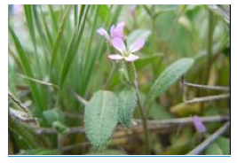
Invasive plants pose a significant threat to native plants and animals by crowding out native food sources, consuming more water than native plants and creating fire hazards or erosion problems. Christy Brigham of the National Park Service and Deborah Estrin, CENS director, developed the applications.
Combating invasive weeds is expensive and time-consuming. Physically mapping the occurrence of invasive species is the first step toward identifying conservation targets and mobilizing weed control. Unfortunately, weed maps become out of date because invasive species grow and spread quickly. Asking visitors to report invasive species via mobile phones provides a simple, cost-effective way to update weed distribution information.
“What’s Invasive!” users can collect and share weed information from any area on the globe. CENS’ other citizen science applications include health- and urban-related mobile phone applications.
To learn more about the project and the “What’s Invasive!” application, visit: whatsinvasive.com

Planet Forward Editorial Assistant | George Washington University

Georgetown University

A project of

in collaboration with