


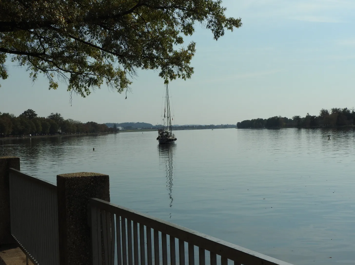
A boat floats in the Washington Channel near the Anacostia Riverwalk Trail.
Erika Filter
February 06, 2024
Erika Filter

If you wanted to walk along the waterfront on the southeast side of Washington, D.C. — past Michelin-star restaurants, gleaming high-rise apartment buildings, and ornate government headquarters — your best bet would be the Anacostia Riverwalk Trail. It runs the majority of the distance, hugging the Washington Channel of the Anacostia River.
It’s a dazzling path to take, but it’s also one that’s under imminent threat.
Between 2010 and 2020, the area of D.C. designated as Ward 6, has seen a 42 percent increase in residents—about 32,000 in total—according to census data, which is more than a third of DC’s overall growth in that period. Even today, after drastic redistricting, it still contains one-sixth of DC’s population.
With such a massive influx of people, there was bound to be development. Ward 6’s beloved waterfront has borne the brunt of it. NoMa went from a couple rows of sparsely populated office buildings to having its own voting precinct. More than two million people now enter Navy Yard annually for Washington Nationals games.

Though this expansion improves everyday life for residents in the area, it’s not without its major drawbacks. Ward 6’s waterfront is already vulnerable to flooding from the Anacostia, but if the construction is to continue, it will only be making the problem worse. Already, residents have begun to notice issues. Molly McManamon, who has lived in the area for five years, said she’s noted drainage issues in Yards Park.
“Everything being on the waterfront here, there’s always going to be a risk of flooding,” McManamon said.
As climate change continues to worsen, the warmer air holds onto more moisture. This can produce longer and more intense rains, enough to kickstart flooding.
“On just one or two days, the rain has just been really, really heavy, as opposed to being more spread out and more sprinkles,” McManamon added.
She said over the past few years, she has noticed rain intensifying in August and September, which makes the Anacostia River swell. She’s not alone in this observation. In 2015, the Southwest Neighborhood Plan identified a 100-year floodplain that was more troublesome than previously expected—partially because of this sudden push for development.
“I pulled up the floodplain map and I noticed that there was this crazy floodplain that bisects the entire community,” said Andrea Limauro, an Environmental Protection Specialist at the D.C. Department of Energy and the Environment. “Smack in the middle of it, we had these three giant public housing communities. And that really concerned me.”

Limauro has been following this issue for eight years now since the Southwest Neighborhood Plan first released those floodplain maps. Only in the last year or so has he been able to make any real progress, establishing the Southwest-Buzzard Point Flood Resilience Strategy. It’s the first in what Limauro is hoping will be a long line of projects aimed at preparing neighborhoods for increased flooding concerns.
Not only is this a monumental push forward, but the location also holds significance. Much of Southwest D.C.’s development began in the 1950s, long before Ward 6’s recent population boom. Under the Redevelopment Land Agency and the National Capital Planning Commission, government planners demolished many homes and black-owned businesses.
“It was the first and biggest urban renewal plan in the country. That’s why Southwest looks so different, you know, so modernized towers in the park.” Limauro said. “Southwest doesn’t have a lot of spaces that are whimsical and natural. It’s very built out.”
This lack of natural space is something Southwest can’t afford. Along with the mental health and sustainability elements associated with greenspaces, exposed earth performs an oft-forgotten function: drainage. Vegetation allows for water to properly infiltrate the soil, and if placed strategically, it can even help divert water to prevent pooling in crucial areas.
The Southwest-Buzzard Point Resilience Project, an initiative of the District Department of Energy and Environment (DOEE), will make use of vegetation, along with new pipes and floodable structures, in order to redirect and slow stormwater. If successful, it will prevent homes and businesses from being the first to flood, improving current-day modeling.
But it’s not just large-scale projects that are tackling the greenspace problems in Ward 6. In fact, they can even serve dual purposes. Coy McKinney, an urban agriculture teacher at Friendship Public Charter School, said he uses the campus’ 20 garden plots and greenhouse to teach students how to care for plants and cook using ingredients they have grown. He said around Christmas 2013, he sent a mass email to local charter school principals expressing his interest in urban gardening. When Friendship Public Charter upgraded its building, constructing the greenhouse, they invited McKinney even though he had no teaching experience.
“They threw me in the classroom,” McKinney said. “And then ever since then, I’ve just been trying to build this program out.”
McKinney also works with Southwest DC Action Network, an advocacy group fighting for anti-racist development and a sustainable neighborhood. This was one group among many that Limauro encountered while working with the community on his project. Though residents of Southwest were often skeptical of government intervention due to the area’s history, McKinney’s work shows how their goals can be synthesized.
Those in Southwest are concerned about the flooding, but many can’t find time to worry about it among their other issues. McKinney cites problems like being “housing [or] food insecure” as the more everyday worries that prevent people from bringing their full selves to the community.
McKinney’s efforts, however, prove that both can be done simultaneously. Collective, community gardens would allow for access to healthy food options and would increase vegetation for better drainage.
It’s just one piece in a significantly larger puzzle, but it’s the small parts that count. After all, Limauro said the future will likely involve more adaptation to increased flooding, with cities adjusting to live with changing waters.
“We’re probably not pushing the envelope far enough compared to what the future might really look like,” he said.
He said the first part of the Flood Resilience Strategy will reach completion in about four years, the culmination of over 12 years of work.
“I hope that we will never need to use it,” Limauro said.

New York University

Planet Forward Correspondent | Northwestern University
A project of

in collaboration with