


Joyce Li
August 09, 2023
Joyce Li
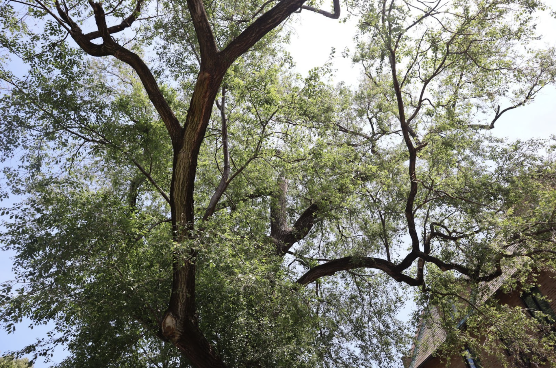
Planting the tip of her shovel into the earth, Leslie Shad pushed down with her full weight and began to dig. The hole needs to be twice as wide as the sapling’s root, she instructed the group of volunteers behind her as she worked.
This past April and May, Shad led volunteers around the town of Evanston, Illinois in an annual spring planting event organized by Natural Habitat Evanston, or NHE, a branch of Climate Action Evanston that she co-leads.
The spring planting event aims to sustain Evanston’s tree canopy, which Shad said is declining every year.
“Generally, we lose 600 trees a year and we plant 400 trees a year,” Shad said. “So we’ve just been in a loss of trees for years and years.”
Shad added that newly planted street trees have an average lifespan of six years. Salt and sidewalk and sewer construction can disturb the trees’ roots, contributing to the city’s loss of trees.
The group added 85 trees to the city this year, most of them on school grounds. But Shad also planted three trees in homes in Evanston’s 5th Ward — part of NHE’s continued effort to increase tree coverage in the city’s historically redlined, predominantly Black neighborhood, which falls below the city average of tree coverage.
Any residents or businesses in the 5th Ward can apply for free trees on their properties, Shad said. Volunteers from NHE would then plant those trees and provide care instructions.
But trees aren’t the only environmental resource that the 5th Ward lacks, according to city data.
Every three years, the city’s Health and Human Services Department releases the Evanston Project for the Local Assessment of Needs, or EPLAN. In the past, the EPLAN has focused on tracking individual health behaviors and outcomes.
However, in 2022, under the new leadership of Community Health Specialist Kristin Meyer, the project took a different approach. It examined the systemic factors that affected residents’ ability to be healthy, taking into account metrics including air quality, walkability and tree canopy coverage.
“We’re going beyond this overly simplistic understanding of individual choice and how they impact health, and instead looking at the systems and environments around us and understanding how they limit or expand our ability to be healthy,” Meyer said.
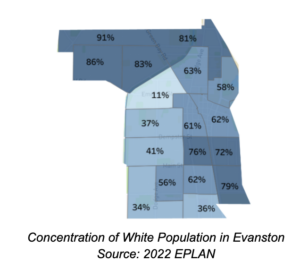
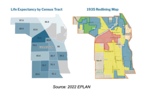
The report found that across Evanston, a resident’s life expectancy can vary up to 13 years depending on the neighborhood they live in. The census tract roughly representing the 7th Ward, an 81% white area with a median household income of $144,853, has the highest life expectancy in the city of nearly 89 years.
On the other hand, another tract that corresponds with the predominantly Black 5th Ward, with a median household income of $44,458, has a life expectancy of 75.5, 6.5 years shorter than the city’s average life expectancy of 82.
The report also highlights the correlation between life expectancy and the city’s history of redlining. A 1935 Home Owners’ Loan Corporation risk map racially segregated the city by outlining neighborhoods from most desirable to least, with the northern 6th and 7th Wards deemed most desirable, while the 5th Ward, where the city segregated Black residents in western Evanston, was labeled “hazardous.”
In the following years, the areas described as desirable on the map would receive the most investment from the city, while the 5th Ward would receive the least, according to the report.
Today, Evanston is still segregated along those same lines. A map from the 2022 EPLAN shows that the areas deemed most desirable in 1935 are still 81% to 91% white. A side-by-side comparison of the EPLAN’s life expectancy map and the 1935 redlining map also reveals stark parallels.
The EPLAN also notes that the emergency room visit rate in Evanston is more than 10 times higher among Black residents than white residents for adults, and about four times higher for children.
While inadequate EPA air sensor coverage makes it difficult to access reliable quantitative data on air quality in Evanston, the EPLAN’s qualitative data shows that the 5th Ward is disproportionately exposed to air pollution due to heavy truck and industrial vehicle traffic. A waste transfer station is also located in the 5th Ward.
Data collected by local organization Environmental Justice Evanston (EJE) found that each day, about 440 diesel garbage trucks pass the waste transfer station, according to EJE co-lead Jerri Garl. The station is only a two-minute drive away from Evanston Township High School.
Differences in tree canopy coverage is another contributing factor. For Meyer, tree canopy is one of the most observable disparities the EPLAN outlines.
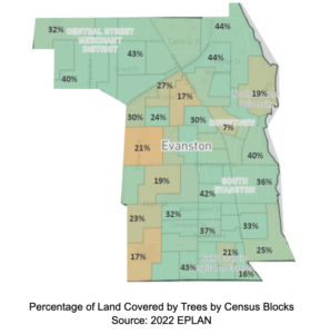
“We see a lot of old growth, these beautiful trees concentrated in the north and eastern portions of Evanston, and then lesser coverage throughout western Evanston,” Meyer said.
Trees can reduce the temperature of their surrounding environment by up to 10 degrees by releasing oxygen and moisture into the air, Shad said. They also have sugar particulates in their leaves that can capture smog and other air pollutants.
One reason the 5th Ward sees lower tree canopy coverage is because of its smaller lot sizes and narrower parkways, according to Meyer and Shad. Meyer added that this is another product of redlining.
“There’s often not enough room in front of buildings to keep public trees,” Shad said.
This is NHE’s third year of offering free trees to 5th Ward residents, according to Shad. However, she said few have expressed interest.
“It’s free trees, so you’d think that people would pick it up, but a lot of people don’t see, necessarily, the benefit of that,” Shad said. “So it’s sort of about outreach and education.”
To promote her program, Shad has been distributing paper door hangers to 5th Ward residents introducing the tree planting program. The advertisements also include a list of the benefits of trees.
So far, NHE has planted 20 trees and 122 shrubs at 27 residences in the 5th Ward.
Beyond individual homes, Meyer said the city is looking at making changes to its zoning code to allow for wider parkways and better tree coverage in the ward.
Evanston’s Comprehensive Plan, which Meyer calls the “North Star” of the city government, is a long term planning document that outlines future physical development in Evanston. The city’s current Comprehensive Plan was adopted in 2000, making it long overdue for an update.
In an interview with The Daily Northwestern, Neighborhood and Land Use Planner Meagan Jones said the new Comprehensive Plan would focus on addressing systemic equalities, including environmental health disparities.
The city also hopes to address the issues raised in the 2022 EPLAN by launching an environmental justice investigation. Sustainability and Resilience Coordinator Cara Pratt said the investigation will help the city identify next steps for combating environmental injustice and climate change. The city allocated $100,000 to the investigation in its 2023 fiscal budget.
“It will be a combination of qualitative and quantitative research,” Pratt said. “So it’s community meetings to understand the lived experience of Evanstonians, but then also some quantitative data gathering — really any metric that we can find data for, related to environmental justice.”
Pratt said many residents and organizations, most notably EJE, have been calling for this investigation for years.
The organization will also be involved in the investigation. Though it is still in its early planning stages, EJE organizers are collaborating with Pratt to draft a request for proposals to hire a consultant to conduct the investigation.
According to Garl, the quantitative aspect of the investigation will involve the creation of a geographic information system that maps out environmental metrics in the city by census block. The qualitative aspect involves more listening sessions with residents, similar to those that EJE has done in the past.
“This is not going to be an academic exercise,” Garl said. “This is truly intended to be one in which residents who are experiencing environmental inequities will have their voices heard, will participate in the process of deciding what’s important “
Though progress has been slow, Meyer is hopeful that the investigation will lead to the city taking more responsibility.
“I think now that we are collecting data in this way, we can really kind of start to hold ourselves accountable,” Meyer said. “Whether we see equity improving down the line or whether we need to advance our efforts on that front, we can’t pretend we don’t know anymore.”

Planet Forward Correspondent | Middlebury College

Program Coordinator | Planet Forward


New York University
A project of

in collaboration with
